Category: Development

A Photo is Worth 729 Words, by Charles Romanow

Photo credits: Madeline Berry

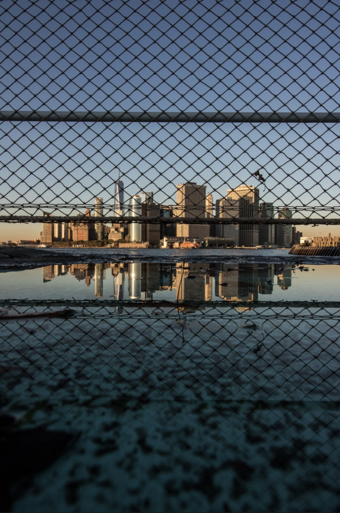
Hundreds of years of development reveal a constantly changing skyscraper-studded Lower Manhattan skyline.  Modern flashy buildings rise while aged relics retreat into the Manhattan schist, the foundation allowing the man-made mountains to protrude.  A slight glimpse of nature hangs off the Financial District at Battery Park. Created by landfill, the manicured space includes a fort, statues, memorials and an unfettered view of the world beyond.  Lying against the East River sits a cluster of 1970’s office towers. Catering to the world’s financial leaders, the buildings’ and their tenants cling to the Financial District through triumph and terror, serenity and flooding.  On either side of the Brooklyn Battery Tunnel entrance lie the International Mercantile Marine Company Building and Whitehall Building. Preserved artifacts each nearly a century old; they await time and surrounding structures to entirely overshadow them.  Built through landfill and enormous wealth, Battery Park City lies on Manhattan’s southwest corner. Sitting neatly between the Hudson River and West Street, the neighborhood’s peaceful streets host an indoor shopping mall and thousands of residents and workers.  West Street and FDR Drive enclose the remainder of Lower Manhattan. Inventions of Robert Moses, the frequently congested highways’ separate New Yorkers’ from the island’s most prosperous resource; water.

Lower Manhattan’s prominent location on the water sped the flow of development and travel.  Millions of people entered America through New York Harbor; gazing at the eternally impressive skyline.  Though once bringing hope to New Yorkers’, the sea creeps ever closer.

Hurricane Sandy flooded the Lower Manhattan skyline.  Sea level rise maps paint a startling picture of a waterfront ¼ mile inland from present.  Communities in Brooklyn, Queens, and Staten Island face more imminent danger. Coney Island, the Rockaways and Midland Beach, like much of New York, developed because of proximity to water.  City government and residents’ face the impossible decision of whether to stay and fight the inevitable or retreat and allocate resources elsewhere. Due to Lower Manhattan’s historical presence and wealth of economic and infrastructural resources, fight they must.  Constructed walls and protections slow disaster while New Yorkers’ wait for miracles to appear beyond our lifetime. New York’s strongest asset becomes its greatest foe.

As sea level rise gradually shrinks the physical envelope of New York City, the universal nature of climate change brings the shared essence of life to the forefront.  The same process affects different corners of the Earth in similar ways. Though having the potential to divide, the existentialist force should instead inspire us to see similarities.  

The water adjacent to Lower Manhattan allows a view of the reflection of our creations.  Together, the most rewarding and hurtful pieces of life manifest themselves in New York. All visitors are able to experience the architectural landscape of the Financial District, but the benefits are not equally distributed.  The early flow of capital through New York Harbor fueled the construction of buildings throughout the City. Further exploration and creation of new markets led to larger and more profitable industries. Maintaining the growth we had become accustomed to required the development of new real estate ventures, such as Battery Park City and Hudson Yards.  Once the only place for capital and wealth in New York, the culture of Lower Manhattan spread across all three hundred miles of the City through real estate development and gentrification. The greater the flow to the top, the larger the divide from the bottom. Emma Lazarus famously stated to “give me your tired, your poor, your huddled masses yearning to breathe free.”  Masses continue to wander into and through New York City. Though no longer living in such crowded, squalid conditions life in New York City remains a battleground.

The photo of Lower Manhattan identifies various facets of New York City.  Once used as a fortification against invaders of Lower Manhattan, Governors Island now provides an oasis from the dense city it protected.  The fence on Governor’s Island obstructs the striking skyline.

The water splits the City while engulfing those closest to it.  Highways separate New Yorkers’ from the peace and tranquility of the Hudson and East Rivers.  The skyline of the Financial District creates an image of prosperity and peace, but blocks the view of poverty and crime beyond.  New York has remained resilient and innovative through natural and human-made terrors. The City’s future remains uncertain; belonging in the hands of all users of the City, particularly planners.


Article published in the Fall Issue of URBAN, Supra. You can access it here.
It’s hard not to notice all the construction going on in New York City. Yet where the average passerby sees only cranes and the hands of private developers reshaping the city, planners, policy-makers and political insiders see the increasingly powerful role of the city’s arms-length organization, the Economic Development Corporation (EDC).

Sometimes referred to as ‘the City as developer,’ EDC seems to have its hands in just about every major development these days. For better or worse, this has given them a lot of attention, yet few people actually understand the purpose of the company and how it operates.

Many people confuse EDC with the Empire State Development Corporation, the state body that invoked eminent domain to expropriate land from Harlem property owners for Columbia’s Manhattanville expansion. The main tasks of EDC is decidedly less hostile: it oversees the sale and development of city-owned property.

Through various fiscal crises and major shifts in the economy during the 1960s and 1970s, many buildings became vacant and derelict throughout the five boroughs. These abandoned buildings and key pieces of infrastructure were taken over by the city in lieu of back taxes with the idea that one day these properties could be fixed up and reused.

In 1966, the City created a Public Development Corporation to oversee a lot of this development. A second entity, the Financial Services Corporation was created in 1980 to administer government financing programs to expand business on many of these vacant properties using local and federal government funds (think incentives). During the 1990’s these two companies were merged to form the Economic Development Corporation.

Added to this mix was the Industrial Development Agency (IDA), whose purpose was to manage finances that specifically pertained to attracting and retaining industrial businesses. Structured similarly to the three corporations that had come before it, this new agency was not a City department, but a not-for-profit corporation. The board of directors were appointed by the mayor, City Council and borough presidents, however it was intended that the IDA would operate as a semi-independent entity. This single corporation was now given the responsibility of ensuring the sale of city land and financing of future uses that benefited the economic health of New York City. Such financing could come in many forms, including municipal funds earmarked by the city council to federally administered new market tax credits and stimulus funds.

But EDC is different from other city agencies in some important ways. For instance, when city-owned properties are sold, the names of the bidders and their projects are not revealed to the public. It is only after EDC selects a developer that the community is informed of the developer’s plans. Unsurprisingly, this process has raised the ire of many New York City communities and made it the target of a public backlash, as was the case in the recent Willets Point and Atlantic Yards development proposals pushed by EDC.

Having many different funding sources gives EDC a lot of power. Add to that its unique semi-public, semi-private status and it is a recipe reminiscent of Robert Moses’ Triborough Bridge Authority, which built countless bridges, tunnels and highways throughout the city with impunity from the 1940s to the 1960s despite much public disapproval.

Although their procedures may not earn the approval of many New Yorkers, EDC’s work is nonetheless vital to the economic success of New York City. Throw a rock and you are likely to hit a project forwarded by EDC, from the Brooklyn Cyclones baseball facility at Coney Island to the new West Harlem Piers Park adjacent to the future home of the new Columbia campus. This summer EDC will oversee the operation of a water taxi service on the East River, the opening of the East River Esplanade park, and the continued growth of business incubators like a kitchen facility for immigrant women in East Harlem to a technology office hub in Hudson Square.

From projects as large as revitalizing the South Brooklyn Marine Terminal — a project that aims to bring thousands of jobs back to the Sunset Park neighborhood and revitalize a freight rail line adjacent to the site — to selling a small lot in Midwood, Brooklyn to a Jewish Day School, EDC is a powerful and omnipresent force in New York City development. Despite their somewhat controversial reputation, EDC’s use of public assets to leverage private development has been instrumental in keeping New York City the business hub of the region.

Ben Huff

Both New York City’s recently opened High Line park, and Los Angeles’ answer to it, the Hollywood Freeway Central Park, are reminiscent of the City Beautiful movement – the turn-of-the- 20th century planning approach responsible for such enduring landscapes as Central Park and Prospect Park. A century later, cities are still building parks that reclaim and readapt space in unconventional ways. Today, new parks not only serve as destination points for residents and visitors, but they act as tools for increasing the city’s global profile.

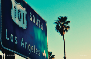
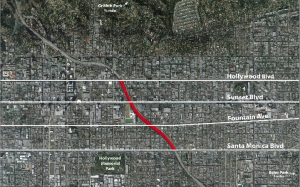
The proposed Hollywood Central Park will run on top of Highway 101 between Hollywood Boulevard and Santa Monica Boulevard. Like NYC’s reengineering of the landscape to create their Central Park was revolutionary for its time, LA’s idea to rethink the purpose of its highways is similarly innovative — a concrete deck will be built above the freeway with soil, plantings and other man-made decorative park elements.

The similarities between the two cities don’t end there. Los Angeles’ motives are only slightly different from those of New York City in the City Beautiful days. Hollywood Central Park will of course serve as a much-needed green oasis in the city of freeways and provide a compelling reason for Angelenos and tourists to get out of their cars. Perhaps more importantly, it is a ‘global city’ branding project that aims to create a unique destination point like New York City’s High Line.

LA’s reputation as the quintessential car city leads many to think of it as ‘park poor’. But many areas in LA boast abundant parks. When the decking project was first proposed, the promoters of Hollywood Central Park asserted that it would bring much needed park space to Los Angeles. But nestled between Griffin Park (LA’s biggest, at 4,210 acres) and Echo Park, and in close proximity to Hollywood Memorial Park, Hollywood Central Park may not be located in a park poor area of Los Angeles. This begs the question, why here?

In most city projects there lies a fine line between needs and politics, and the reality is that it is hard to get unconventional projects built without the backing of an influential City official. A project like Hollywood Central Park is controversial and very expensive. When it was first proposed, some thought it was more of a Hollywood dream than a real project. Today those sentiments are all but memories.

Eric Garcetti, the local area councilmember and LA’s City Council President (and a Columbia alum), is the political muscle behind this project. Even though there are only a few stretches along the freeway that are suitable for a decked park, his support answers the question of location — the project needs to be within his district’s political boundaries to justify his level of support.

In 2006, the Hollywood Chamber of Commerce unveiled the first iteration of the plan, stretching the park between Hollywood and Sunset Boulevard. In 2007, Garcetti led a City Council vote that expanded the project to Santa Monica Boulevard, increasing the proposed parkland to 44 acres. Even though the project will be mostly funded by foundations, the council president’s support is crucial to getting a project of this scope and cost (estimated at $950 million) built.

Park support continues to grow. Friends of Hollywood Central Park is a non-profit organization that advocates full-time for the realization of the park. The California Endowment, the William and Flora Hewlett Foundation, and the California Wellness Foundation have all been identified as potential funders. Last year Congressman Xavier Becerra (D-Los Angeles) also agreed to request $5.85 million from the federal government to help build the park.

Hollywood Central Park is part of the ongoing effort to revitalize Hollywood by rethinking its brand and making it a more livable community and a more dynamic tourist destination. From both a resident’s and a tourist’s perspective, Hollywood Central Park is a good thing. The increased vertical density that results from LA’s recent densification means that there are fewer private lawns that Angelenos can enjoy during the weekend.

At the same time, a big complaint about LA from tourists is that all of the attractions are sprawled out in different neighborhoods, which makes touring the city very difficult. Hollywood Central Park will be between Hollywood and Downtown LA (both well-served by transit) and should increase connections between both neighborhoods. Hopefully it will also ameliorate some of the city’s car dependency by re-greening part of the infamous concrete network of LA’s freeways. Only then might it enter the pantheon of the world’s great parks.

By Claudia Huerta

In just the last decade, New York has changed to an astonishing degree. Just ask Columbia urban planning alumnus Tom Lunke. For the past 12 years, the class of ’95 grad has been the planning director of the Harlem Community Development Corporation, where he has witnessed first hand the evolution of the neighborhood and been an insider in some of the more heated public debates, including the Manhattanville expansion plan.

URBAN met with Lunke to hear about his experiences in Harlem.

URBAN: What kind of work have you been doing with the Harlem Community Development Corporation (HCDC)?

Lunke: I’ve ended up doing a lot of public space projects dealing with either creating new space or expanding old space or redesigning it in some way with the community’s input.

URBAN: Have you built good relationships with the community as director of the HCDC?

Lunke: When I first came here, people looked at me like I was from Mars. There were very few white people in Harlem at that time, and it was under a republican administration so they thought, “ok, here’s a republican coming in and he’s not necessarily going to care about what our needs are.”

So I worked really hard to basically turn that myth on its head and show that I was here for them and that basically I could be a conduit between the interests downtown and their interests, and that I would be an honest conduit.

URBAN: Have you witnessed much change in Harlem since you first began working?

Lunke: Oh yeah. When I first came here [twelve years ago] it was really something else. There was still a lot of poverty. I mean, now you see poverty in the people on the street, especially on 125th street. But when I first came here you saw a lot of the physical poverty in the structures.

You would go walk down a street and smell mold, because there
were so many buildings that had been left abandoned that they were basically molding. So there was a very kind of musty smell on many of the side streets. You don’t have that any more because so much of these streets have been redeveloped.

URBAN: If I remember correctly, HCDC opposed Columbia’s Manhattanville expansion plan that called for the use of eminent domain which was ultimately approved by the State Supreme Court. How do you look back on that experience?

Lunke: That was a real struggle. What was clear from the beginning was that Columbia was only interested in acquiring all the property for what is essentially a 17th century campus plan. What we tried to get them to think of was…a Columbia of the 21st century, where their project would be integrated into the fabric of the existing community.

URBAN: What do you mean by 17th century?

Lunke: The plan for the future campus in Manhattanville…is essentially a quad with buildings around it. And the way it’s built, even if they have streets going through it, psychologically it’s an isolating campus.

We [the HCDC] asked them to look at not acquiring all the property, but leaving those businesses that wanted to remain and being aware that there are independent voices within this larger context so that land isn’t controlled by a single entity and is therefore making a single decision.

URBAN: So something with a greater mix of uses, essentially?

Lunke: They were talking about…the importance of interdisciplinary dialogue. What I tried to explain to them is that interdisciplinary dialogue isn’t just one department talking to another, but it’s a department talking to the outside world and getting ideas to apply within the department.

If Columbia wants to be at the cutting edge, [it needs to speak] with people who are on the streets. Not all the greatest ideas come from above and go down. You can get the reverse. And so if we’re talking about a creative economy, well, that involves everybody; everybody thinking and discussing and comparing.

By Jake Schabas

© 2024 URBAN Magazine

Theme by Anders NorenUp ↑